There are multiple bus, light rail, and commuter rail systems in Washington that service various parts of the city, making the city’s public transportation network fairly comprehensive. The Metrobus and Metrorail systems, both of which are run by the Washington Metropolitan Area Transit Authority, are the most popular forms of public transportation in the city. While the Metrorail system is an underground light rail network with 97 stations, the Metrobus system covers more than 300 routes throughout the city and its environs. The District of Columbia (DC) Circulator, the District of Columbia (DC) Streetcar, and the Metropolitan Area Commuter Rail Service (MARC) are some of the other modes of public transportation that are available in the city. A good number of these services provide riders who are students, pensioners, or disabled with discounts on their fares.
Metro system in Washington – Basic information
The Washington Metropolitan Area Transit Authority (WMATA) operates one of the most crowded and heavily used metro systems in the United States. It was founded in 1976 and provides service to the District of Columbia in addition to portions of the states of Maryland and Virginia. It is made up of six lines that collectively provide service to 97 stations. The Washington Metropolitan Region Transit Authority is in charge of the trains, which ensure that commuters in every part of the metropolitan region have access to dependable transportation.
The lines of the Washington Subway system
Red Line – “U”
Between Montgomery County, Maryland, and Washington, District of Columbia, the Washington Metro Red Line has 27 stops. The Red Line serves the nation’s capital. The system’s oldest and busiest line travels through downtown Washington. It has two terminal stations at Shady Grove and Glenmont and is fashioned like a “U.” During morning and evening rush hours, train arrivals average four to eight minutes, while after 9:30 p.m., they average 15 to 18 minutes. After then, trains run less.
Blue line
The Washington Metro’s Blue rapid transit route has 27 stops in Fairfax County, Alexandria, Arlington, Washington, DC, and Prince George’s County, Maryland. The Downtown Largo Blue Line begins at Franconia–Springfield Station. This route shares tracks with the Orange, Silver, and Yellow lines at 13 stations, 18 stations, and 6 stations, respectively. Three stations are Blue Line-only.
Orange line
The Washington Metro’s Orange line has 26 stations in Fairfax County, Arlington, the District of Columbia, and Prince George’s County, Maryland. The line serves Fairfax County, Arlington, DC, and Prince George’s County, Maryland. The Orange Line runs from Vienna, Virginia, to New Carrollton, Maryland. This route shares stations with the Silver and Blue Lines.
Yellow line
The Yellow route, a WMATA rapid transit route, links the Huntington station in Virginia to the Greenbelt station in Maryland. It has 21 stations in Fairfax County, Alexandria County, Arlington County, Washington, DC, and Prince George’s County, Maryland. The Yellow Line runs between King Street–Old Town and the Pentagon with the Green and Blue Lines. L’Enfant Plaza to Mount Vernon Square is the Green Line’s northern section. Huntington and Eisenhower Avenue are the only non-shared stations on this line. The portion south of King Street–Old Town and the section that crosses the Potomac River between the Pentagon and L’Enfant Plaza stations are the line’s only two unshared sections. This line has both portions.
Green Line
The Washington Metro Green Line travels through Prince George’s County in Maryland and the District of Columbia. It has 21 stops. Greenbelt’s Green Line begins at Branch Avenue. One of three north–south lines in Washington, it was the last line built in the original Metrorail plan. The Yellow and Green Lines share rails between L’Enfant Plaza and Greenbelt.
Silver Line
The Washington Metro’s Silver Line runs through Loudoun County, Fairfax County, Arlington County, Washington, DC, and Prince George’s County, Maryland. 34 stops are split throughout four jurisdictions. The Silver Line links Ashburn, Virginia, to Downtown Largo, Maryland. Ashburn, Virginia. Five Blue Line stations are shared between Downtown Largo and Benning Road. The Orange and Blue Lines share thirteen stops from Stadium–Armory to Rosslyn. Five stations share the Orange Line from Court House to East Falls Church.
Map of Washington Metro 2023 – Free Download in PDF
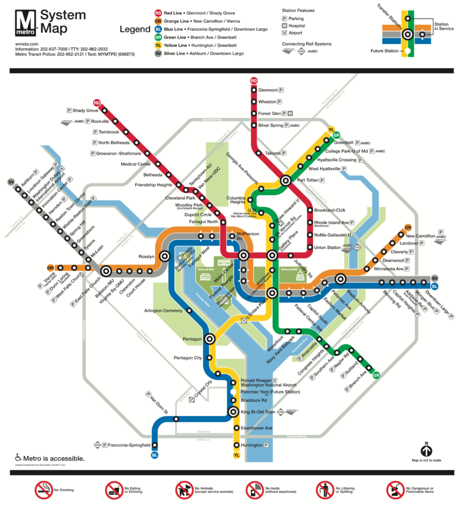
Click on the image and download the map of Washington´s underground system for 2023
Those who are interested in exploring the Washington, DC, area will find the Washington Metro 2023 map to be a very helpful resource to have on hand. You may get an up-to-date glance at the whole metro system, including stations, lines, and transfer locations, by downloading this free PDF and opening it on your computer. Using this map, it will not be difficult for you to plan your itinerary, and you will be able to move swiftly and effectively across the city. This free map is a fantastic resource to have on hand, regardless of whether you are a resident of the area or a visitor.
Public transport tickets in Washington – Best types for travelers & actual prices
Because there is such a wide choice of tickets for the city’s public transit system, getting around Washington, DC is now simpler than it has ever been. There are many kinds of tickets available depending on whether you are a local or a visitor to the area. In the nation’s capital, there are a variety of different ticket options for public transit, ranging from single-ride tickets to multi-ride cards.
Metro SmarTrip Card
The most common form of payment utilized by commuters in the Washington, DC, metropolitan region is the Metro SmarTrip Card. It is a card that can be reloaded with money and used to pay for rides on the Metrobus and Metrorail systems. A card can be purchased for $2, and then money can be loaded onto it for use on the rides. You will be charged $2.25 for each ride, and the card will keep track of how many rides you have taken and subtract the amount from your remaining balance. You also have the option to purchase a 7-day fast pass for $59, which grants you unlimited trips on Metrorail and Metrobus for the duration of the pass.
Ticket for the DC Circulator Bus
Everyone, from visitors to long-time residents, can benefit from purchasing a ticket for the DC Circulator bus. There is a one-dollar flat rate charge for each ride, regardless of how far you are traveling. You can buy tickets from the bus driver or use the DC Circulator app on your mobile device. The tickets are good for two hours and can be transferred to any other bus service during that time.
Regional Bus Ticket
If you intend to travel outside of the city borders of Washington, District of Columbia, you should probably look into purchasing a regional bus ticket. These tickets are good for travel on regional buses, the DC Circulator, and the Metrobus. You can buy a ticket for a single journey for $3.75, a pass good for seven days for $17.50, or a pass good for thirty-one days for $64.50 on the regional bus system.
Capital Bikeshare
Capital Bikeshare is an option worth thinking about if you’re interested in finding ways to travel around town that are easier on the environment. Through the use of this system, you will have the ability to hire a bike from any of the Bikeshare stations located across the city. You can get a ticket for a single ride for $2, or you can get a pass good for 24 hours for $8.
The best ticket option for travelers staying in Washington, DC for a total of three days is the seven-day fast pass that can be loaded onto the Metro SmarTrip Card or the seven-day regional bus pass. The duration of your trip is covered by both tickets, giving you access to unlimited rides on the Metro as well as regional buses. This is a wonderful opportunity to save money while still discovering everything that Washington, DC has to offer.
Timetables & Schedules of the Washington Metro system
The Washington Metropolitan Area Transit Authority (WMATA) operates its subway system from 5:00 am to 11:30 pm Monday through Thursday, 5:00 am to 1:00 am Fridays and Saturdays, and 7:00 am to 11:00 pm on Sundays. During peak hours, trains arrive at each stop at a frequency of around once every ten minutes and then depart shortly after. The frequency of train arrivals and departures during off-peak hours is roughly once every 15 minutes. Because the precise hours of departure change from station to station, it is imperative that you check the specific timetable that applies to your station.
What Are Other Options For Public Transportation In Washington?
Public transit is an essential component of day-to-day life for people who live in the Washington, District of Columbia metropolitan region. In spite of the fact that the Metro is the most well-known type of public transit in the region, there are other choices available for navigating the area. In the following, we will examine the several forms of public transportation that are available in Washington, District of Columbia. These will include buses, trams, and ferries.
Buses
The Washington Metropolitan Area Transit Authority (WMATA) is in charge of the city’s large bus network, which connects all neighborhoods. The bus system covers the entirety of the city and makes it simple to reach any part of it. Buses are accessible to those using wheelchairs and are available 24 hours a day, seven days a week.
Trams
The current tram system in Washington is known as the DC Streetcar. It connects numerous different communities in the Northeastern part of Washington by traveling along H Street and Benning Road. When there are a lot of people using the trams, it runs every 10 minutes; when there are fewer people using it, it runs every 15 minutes.
Ferries
The Potomac Riverboat Company operates a ferry service that connects Georgetown and Alexandria. The ferry runs from April until October and provides passengers with breathtaking vistas of the Washington Monument and the Potomac River. The ferry makes stops at both the National Harbor and Old Town Alexandria, making it convenient to visit several of the area’s most visited tourist destinations.
These are just some of the many alternatives for public transit that are available in the District of Columbia. It doesn’t matter if you’re seeking a ride on the subway, a bus, a tram, a ferry, or an opportunity to share a ride; there are plenty of transportation choices available. Don’t just stick to the metro; instead, investigate the several alternative modes of public transit that the District of Columbia has to offer.
How To Get From Washington Dulles International Airport (iad) To The City Center With Public Transport?
The bus is by far the most well-liked mode of transportation between Dulles International Airport and the core of the city. The West Falls Church station on the Washington Metro Orange Line is served by the Washington Flyer bus service, which travels between Dulles International Airport and the station at West Falls Church. The bus leaves the terminal every half an hour, and the fare is $5 per passenger. You may go to the heart of the city by taking the Orange Line train from the station on the Metro, which will take around half an hour.
You also have the option of using a private vehicle service, such as Uber or Lyft, which will allow you to travel in greater comfort than public transportation. Although the costs of these services might range anywhere from $50 to $100, you should budget approximately $75 to reach the heart of the city.
No matter the mode of transportation you use, taking public transportation to go from Dulles International Airport to the heart of the city is going to be the most time- and cost-effective option. You can easily and quickly arrive at your location by using the Flyer bus, utilizing a taxi, or hiring a private vehicle service.
What kind of sightseeing do you have to see if you visit Washington for the first time?
The state of Washington is stunning and has a lot to offer, including imposing mountains, lush woods, and rolling hills. Washington has plenty to offer everyone, from the energetic city of Seattle to the serene countryside of Spokane. Choosing what to see and do while visiting can be challenging because there is so much to discover. Here are some of Washington’s best tourist destinations to help with your planning.
- Olympic National Park is the first item on the list. This park, which covers around a million acres, contains a range of landscapes, such as temperate rainforests, the wild Pacific coast, and snow-capped mountains. Olympic National Park is a must-see for everyone traveling to Washington because it offers a wide range of activities for visitors.
- The famous Space Needle in Seattle is the next stop. From its observation deck, this 605-foot tower offers breathtaking views of the city. One of Seattle’s most recognized structures, the Space Needle offers visitors a fantastic vantage point from which to overlook the city.
- Visitors to Seattle can check out the Museum of Flight for a more informative experience. This museum is home to a large collection of international space and aircraft relics. Visitors may even get up close and personal with some of the aircraft, making it an excellent location to learn more about the history of aviation.
- Some of the nation’s most spectacular natural beauties can be seen in Washington. Given its breathtaking waterfalls, forests, and canyons, a trip to the Columbia River Gorge is a need. In order to see the breathtaking views and understand the force of nature, visitors can also hike along the Pacific Crest Trail.
- The majestic Mount Rainier must be seen during any trip to Washington, D.C. One of the most photographed mountains in the nation, this 14,410-foot peak is a wonderful location to see Washington’s stunning natural surroundings.
Washington offers something for everyone, whether you’re seeking a scenic excursion or an educational encounter. There are many sights to discover in Washington, from the magnificent Olympic National Park to the well-known Space Needle. So prepare for an unforgettable trip by packing your baggage.
Summary of our tour guide for Washington
The capital city of the United States, Washington, D.C., is a bustling place with many of tourist attractions. It has a comprehensive, functional, and economical public transit system. The city and its suburbs are connected by the Metrobus, MetroRail, and Capital Bikeshare systems, making it simple to travel to all the well-known locations. The National Mall, the Tidal Basin, and other public parks are just a few of the places where it’s possible to move around on foot. For anyone wishing to visit and see the capital of the United States, Washington, D.C. is the perfect place.
Top 5 FAQs and answers about Washington public transport?
What kinds of public transportation are offered?
- There are several different public transportation alternatives in Washington State. This applies to commuter rail, light rail, buses, and ferries. The Washington State Department of Transportation (WSDOT) runs each of these services.
What is the cost of using public transportation?
- Depending on the service you utilize, public transportation in Washington can be expensive. Bus and ferry prices, for instance, can cost between $1.50 and $3.25, while light rail and commuter rail fares might be anywhere from $2.25 and $10.
Is there a travel planning app I can use?
- Yes! A mobile app from the WSDOT named “Washington Public Transport” offers real-time data, schedules, prices, and other information. You may also schedule travel and buy tickets using it.
Are there any special offers?
- Yes. Reduced rates are one of the several reductions that WSDOT provides, including those for seniors, students, and those with disabilities. Discounted rates are available for both group travel and transit passes.
Is there a website with details on public transportation?
- Yes. Information regarding public transportation in Washington is available on the WSDOT website. Along with maps, prices, and schedules, it also offers practical information and ideas.
Useful links






1 thought on “Washington Metro”