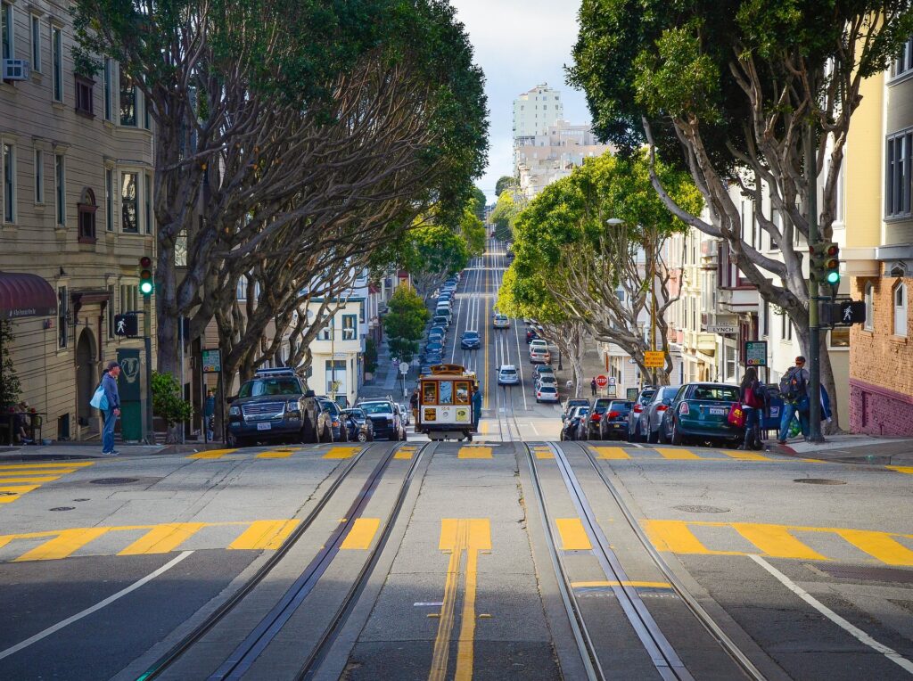
San Francisco has an extensive public transportation system with numerous bus, light rail, and cable car routes. Several lines of public transportation, including the well-known cable cars, are run by the San Francisco Municipal Transportation Agency (SFMTA). San Francisco’s public transportation is dependable and effective, but it can be challenging for first-time tourists to figure out. Depending on the distance and mode of travel, public transportation might be expensive, although passes and prices can be bought online or at numerous neighborhood shops. To assist people in determining the optimal route for their requirements, the SFMTA also offers a useful Trip Planner.
Metro system in San Francisco – Basic information
There are numerous lines and stations spread out across the entire city in the enormous public transportation network known as the San Francisco Metro. Almost 200 million people use it annually, and the San Francisco Municipal Transportation Agency runs it. The BART system, the region’s fast transit rail system, as well as light rail lines, cable cars, and buses, are all included in the metro system. The city’s transportation network includes more than 50 BART stations, additional stations for other rail systems, and numerous bus stops. The metro system offers a practical means to navigate around the city and is open twenty-four hours a day, seven days a week.
The lines of the San Francisco subway system
Orange Line (Berryessa/North San José station to Richmond station)
It has stops in 21 cities, including San Jose, Milpitas, Fremont, Union City, Hayward, San Leandro, Oakland, Berkeley, El Cerrito, and Richmond. The only one of the five main BART routes that don’t go to San Francisco through the Transbay Tube but shares tracks with the other four main trains in the East Bay.
Yellow Line (Antioch station to San Francisco International Airport station)
When the Red Line is not operating, select morning trains, and all trains after 9 p.m. are extended from SFO to Millbrae station. In Antioch, Pittsburg, Bay Point, Concord, Pleasant Hill, Walnut Creek, Lafayette, Orinda, Oakland, San Francisco, Daly City, Colma, South San Francisco, San Bruno, and Millbrae, it serves 28 stations. It’s BART’s busiest line and the only one with short-turn trains. Two sections make up the line. The remainder of the route shares tracks with the other four mainline services and uses BART’s electric multiple-unit trains. Headings and station details show the line’s final destination on maps.
Green line (Berryessa/North San José station to Daly City station)
Its 22 stations include San Jose, Milpitas, Fremont, Union City, Hayward, San Leandro, Oakland, San Francisco, and Daly City. BART’s four main lines share tracks. Since February 2022, the line operates everyday till 9 p.m. Timed transfers at Bay Fair station are available on the Orange Line and Blue Line.
Red line (Millbrae station to San Francisco International Airport station)
Experience the best of the Bay Area with BART! With 24 stations including Richmond, El Cerrito, Berkeley, Oakland, San Francisco, Daly City, Colma, South San Francisco, San Bruno, and Millbrae, you’ll have access to all the must-see destinations. Don’t miss out on the adventure! #BART #BayArea #TravelGoals As a travel influencer, I must say that the line and the other five mainline BART trains share tracks, making for a truly unique and efficient transportation experience. Experience the convenience of seamless travel with the Orange and Yellow Lines! Enjoy a hassle-free journey with timed cross-platform transfers at the MacArthur and 19th Street Oakland stations.
Blue line (Dublin/Pleasanton station and Daly City station)
In Dublin, Pleasanton, Castro Valley, San Leandro, Oakland, San Francisco, and Daly City, it has 18 stations.
Beige line (Coliseum station and its Oakland International Airport station
During planning and construction, it was known as the Oakland Airport Connector (OAC). The AirBART line has replaced the shuttle bus service. There are plans for a third intermediate stop (Doolittle station) to be built in the future on the system, which now only connects two terminal stations. There are 438,800 riders on the line as of the fourth quarter of 2022, or around 1,400 riders every day.
Map of San Francisco Metro 2023 – Free Download in PDF
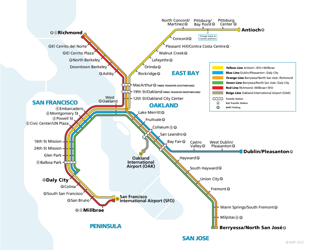
Click on the image and download the map of San Francisco´s underground system for 2023
Everybody who lives in or travels to the San Francisco area must have a copy of the San Francisco Metro 2023 map. It gives a thorough overview of the city’s transit system, highlighting all the stations, stops, and lines. The map is simple to obtain and utilize because it is freely downloadable in PDF format. The San Francisco Metro 2023 map makes it simple to plan your travel around the city and locate the way to your destination.
Public transport tickets in San Francisco – Best types for travelers & actual prices
Whether you’re a local of the Bay Area or a visitor, figuring out San Francisco’s public transportation can be challenging. To make your travel simple, a number of ticketing alternatives are available. There are several rates and ticket options available depending on your needs.
The Clipper Card is the most straightforward ticketing method. The majority of public transit systems, including BART, MUNI, Caltrain, and Golden Gate Transit, accept this reloadable card. Online, at partner merchants, or at kiosks at the San Francisco International Airport, the card can be replenished. The number of trips made and the type of service used affect the price.
The MUNI Passport is an excellent option for individuals seeking a more affordable solution. Users of the MUNI buses, light rail, and cable cars are granted unlimited travel with the Passport, a monthly pass. Tickets for adults begin at $74 and for children at $36.
The CityPASS is the ideal choice for visitors to San Francisco. The California Academy of Sciences, the Exploratorium, and the Aquarium of the Bay are just a few of the five most visited institutions in San Francisco that can be visited with this ticket booklet, saving guests up to 42% on admission costs. A 7-day Muni and Cable Car Passport are also included with the CityPASS, allowing users unlimited travel on all MUNI buses, light rail, and cable cars for that period of time. For visitors staying in San Francisco for three days or longer, the CityPASS is very cost-effective and the best option.
There are numerous ticket choices available in San Francisco to meet everyone’s demands. There is something for everyone, including the CityPASS and the Clipper Card. The CityPASS is the best choice for those who will be in San Francisco for three days or more since it provides excellent value and unrestricted access to MUNI buses, light rail, and cable cars.
Summary of fares for public transport in San Francisco
- MUNI Passport is a monthly pass that allows unlimited usage of MUNI buses, light rail, and cable cars.
- Clipper Card is a reloadable transport card that is accepted on BART, MUNI, Caltrain, and Golden Gate Transit
- CityPASS is a San Francisco ticket booklet that provides up to 42% discount and a 7-day Muni & Cable Car Passport for unlimited travel.
Timetables & Schedules of the San Francisco Metro System
Every day of the week, from 5 a.m. to midnight, the San Francisco Metro system is open. Trains arrive on workdays every five to fifteen minutes, depending on the time of day. Although the frequency of trains is slightly lower on weekends, they still arrive every 20 minutes. Trains run every 30 minutes from 5 a.m. to midnight in the San Francisco Metro system during holidays. The San Francisco Metro system makes it simple to get around the city and offers service to the city’s many well-known attractions as well as the San Francisco International Airport.
What Are Other Options For Public Transportation In San Francisco?
The thriving city of San Francisco is well-known for its distinctive architecture, thriving culture, and multicultural population. For many residents of the city and the surrounding area, public transit is an essential component of daily life because it is a major metropolis. Although the San Francisco metro is the most popular public transportation option, there are alternative choices for those seeking a more distinctive travel experience.
For commuters who like to avoid the inconvenience of driving, the San Francisco Bay Ferry is a fantastic option. This service covers routes connecting the cities of San Francisco, Oakland, Alameda, Vallejo, and South San Francisco and operates seven days a week. The ferries operate a fleet of cozy boats with facilities like free WiFi and bike racks.
Another well-liked means of transportation in San Francisco is biking. The city is a wonderful alternative for individuals who want to move around quickly because it has several designated bike paths and lanes. Users of the San Francisco Bike Share program can borrow bikes from different bike-sharing locations and return them to a different location after their journey is finished. The program offers a reasonable opportunity to see the city while also getting some exercise.
The city’s public transportation system, the San Francisco Municipal Railway (Muni), is a fantastic choice for commuters. In the city, Muni runs buses, streetcars, and cable cars that make it simple to go to well-known locations like Union Square or the Golden Gate Bridge. In order to further reduce the cost of using public transportation, Muni also provides a number of passes and discounts.
In San Francisco, consumers may now use ride-hailing services like Uber and Lyft to make a ride request from their smartphone. Although they are more expensive than other forms of public transit, these services are excellent for people who want to travel swiftly and easily.
In conclusion, San Francisco offers a wide range of public transit choices. The San Francisco Bay Ferry, biking, the Muni, or ride-hailing service are just a few of the alternatives available to visitors for getting around the city.
How To Get From San Francisco International Airport (sfo) To The City Center With Public Transport?
There has never been a simpler way to get from San Francisco International Airport (SFO) to the city core. You can get to your location fast and easily with the use of public transit. Here are the specifics on how to use public transportation to travel from SFO to the city center.
The BART (Bay Area Rapid Transportation) system is the first available alternative. All SFO visitors can reach the BART station, which is inside the International Terminal. You can go to downtown San Francisco on the BART in under 30 minutes. To ensure you receive the most recent departure times, check the BART schedule in advance.
Using the SamTrans bus is the alternate choice. The San Mateo County Transportation District runs the SamTrans bus system. For those who wish to avoid the bustle of the BART, this bus system is a fantastic alternative because it travels every 15 minutes from SFO to the city center.
Use a taxi or use a ride-sharing service to get from SFO to the city center as your third choice. For tourists who don’t want to wait for the BART or SamTrans bus, this is the most expensive but most practical choice. You can find taxis and ride-sharing services right outside the airport building, and they can often take you there in approximately 25 minutes.
What kind of sightseeing do you have to see if you visit the San Francisco for the first time?
One of the most well-liked travel destinations in the country is San Francisco, the stunning city by the bay. There is something for everyone to enjoy in this city with its recognizable landmarks, exciting neighborhoods, and breathtaking views. Here are the best San Francisco sights to see, whether you’re a seasoned traveler or a first-time visitor.
- The Golden Gate Bridge is the first item on the list. This famous suspension bridge, which spans more than 1.7 miles, is one of the most identifiable structures in the entire globe. Visitors can take in breath-taking views of the San Francisco Bay and the surrounding area from the bridge.
- Alcatraz Island is the following. Alcatraz Island, a former jail that is now a well-liked tourist destination, is only 1.25 miles from San Francisco. Guests are welcome to tour the facility, discover its past, and enjoy the breathtaking city views from the island.
- After seeing Alcatraz Island, don’t forget to visit Fisherman’s Wharf. Fisherman’s Wharf, which is near the water, is a well-liked spot for both locals and visitors. You may shop, eat, and visit a number of the area’s attractions, including historical ships, museums, and hands-on exhibitions.
- The Palace of Fine Arts is the last sight to see in San Francisco. This magnificent edifice is a survivor of the 1915 Panama-Pacific International Exposition and is situated in the Marina neighborhood. Guests are welcome to stroll around the property and see the stunning architecture.
These are just a few of San Francisco’s many tourist attractions. San Francisco is a popular tourist destination because of its well-known landmarks, exciting neighborhoods, and breathtaking views. Whether you’re a seasoned tourist or a first-time visitor, be sure to include these attractions on your itinerary.
Summary of our tour guide for San Francisco
San Francisco is an energetic, culturally rich city. Its diversified population gives the California Bay Area’s cultural and financial center, which serves as home to its, life. San Francisco has excellent public transportation, with the BART (Bay Area Rapid Transit) system offering easy access to all of the city’s neighborhoods. It is also simple to navigate around the city because of the substantial bus, light rail, and cable car service provided by the San Francisco Municipal Railway (MUNI). San Francisco is a wonderful city to explore with so many public transit alternatives.
Top 5 FAQs and answers about San Francisco public transport?
What kinds of public transportation are offered?
- The bus, light rail, cable cars, streetcars, and ferry systems are part of the public transportation network in San Francisco. The buses run often and cover the majority of the city. Driving is a great alternative because of the light rail that connects neighboring areas and downtown San Francisco. In addition, there are streetcars, ferries, and cable cars that can be used to navigate the city.
Do I need a ticket to enter?
- You must buy a ticket or a Clipper card to use San Francisco’s public transportation system. Buses, light rail, cable cars, and ferries all accept the prepaid, reloadable Clipper card.
Are there any special offers or discounts?
- Some discounts are available for San Francisco public transportation, yes. Discounted rates are provided for students, pensioners, and those with disabilities, and individuals who frequently use the public transportation system can purchase monthly passes. The Clipper card also provides discounts for multiple rides and for taking public transportation during specific hours of the day.
How safe is the public transportation system?
- The public transportation system in San Francisco is secure, yes. Security cameras are installed in every bus and rail, and police officers are frequently present. To board the buses and trains, travelers must also go through security screenings.
Are there any further amenities?
- Certainly, a number of facilities are provided by the San Francisco public transportation system to make your trip more comfortable. There is air conditioning aboard many buses and trains, and some also have power outlets and Wi-Fi. In addition, every rail and bus has wheelchair accessibility, and the majority of stops feature ticket kiosks and information offices.
Useful links

